Large Scale Earthquake (Fault) Impact Analysis, Scenario Elaboration, and Protection Mechanism
Project Purpose
The compound disasters caused by the 2011 Tohoku earthquake and tsunami attracted Taiwanese people’s attention to large-scale earthquake disasters. Several disaster-prevention countermeasures for large-scale earthquakes have been enacted by Japan: the Large-Scale Earthquake Countermeasures Act (LECA), The Earthquake Countermeasures for the East (Japan) Sea, Southern East Japan Sea, and South Japan Sea, and the Earthquake Countermeasures in the Capital Regions. The United States has also promoted the Public Building Safety Act and California Earthquake Hazard Reduction Program. The current programs in Taiwan related to earthquake disasters are the Basic Disaster-Management Plan (Executive Yuan), the Disaster-Management Operational Plan (at the department and division levels), and the Regional Disaster-Management Plan (at the regional government level). Currently, the disaster management plans of various counties and cities do not incorporate concrete strategies for disaster reduction and management based on scenario analyses of large-scale earthquake disasters. In addition, current assessment techniques regarding large-scale effects and damage are inadequate for conducting large-scale earthquake scenario analyses.
In this project, we are using the greater Taipei region as an example to examine and integrate current techniques based on the possible disaster effects and urban functional failures caused by large-scale earthquakes. In addition, we are developing relevant assessment technologies to compensate for the present technological inadequacies, and quantitatively analyzing the potential large-scale earthquake effects on the greater Taipei region to specifically formulate disaster prevention and management plans under different seismic intensities. Furthermore, by integrating assessment technologies, this project is aimed at establishing an environment for testing relevant assessment technologies in Taiwan and an expert review mechanism for updating and applying future assessment technologies, especially for the effect of the long period seismic waves and long shaking duration in basin. Subsequently this project will collate related analysis methods and applicable technologies to form standard operating procedures (SOPs) and practice the drill similar to the shakeout exercise. The implementation results are expected to serve as a reference when developing relevant plans in other urban areas of Taiwan. In addition, the critical infrastructure (CI) is the key issue as well, the work items including CI information and data collection schemes, and CI risk survey spreadsheet.
Primary Tasks
The current goal of this project is to establish earthquake impact analysis models for disaster reduction of urban areas . In normal time, the impact analysis can assist the Disaster Prevention and Protection Expert Consultation Committee of Executive Yuan to set up protection mechanism and evacuation plan under different seismic intensities. In an emergency, evaluation of seismic risk is provided to the CEOC to identify damage-prone potential areas.
- Establish earthquake impact analysis model for urban area protection and develop an information platform
- Demonstrate 3D graphics for earthquake emergency response and establish automatic presentation compiling system
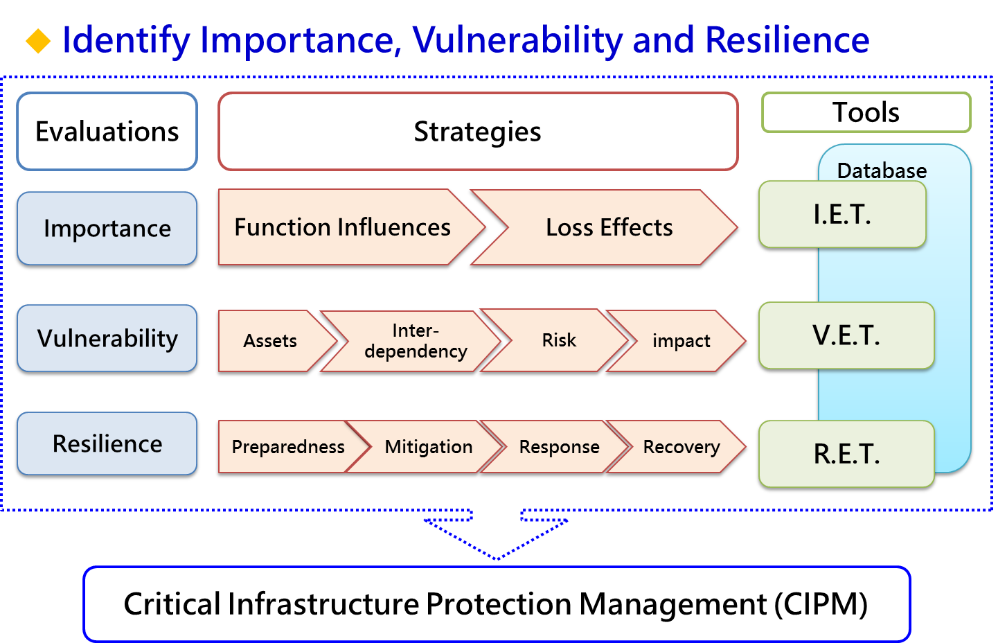
- Develop the Critical Infrastructure Protection Management (CIPM)
Key Achievements
- Developed 「Taiwan Earthquake Impact Research and Information Application (TERIA) Platform」
- Grid-based information of infrastructure over Taiwan with cell size of 500m x 500m
- Platform characterized with both quantitative evaluation and spatial distribution
- Established earthquake impact analysis model for urban area protection
- Utilized grid-based analytic technology to identify weak point of critical infrastructure
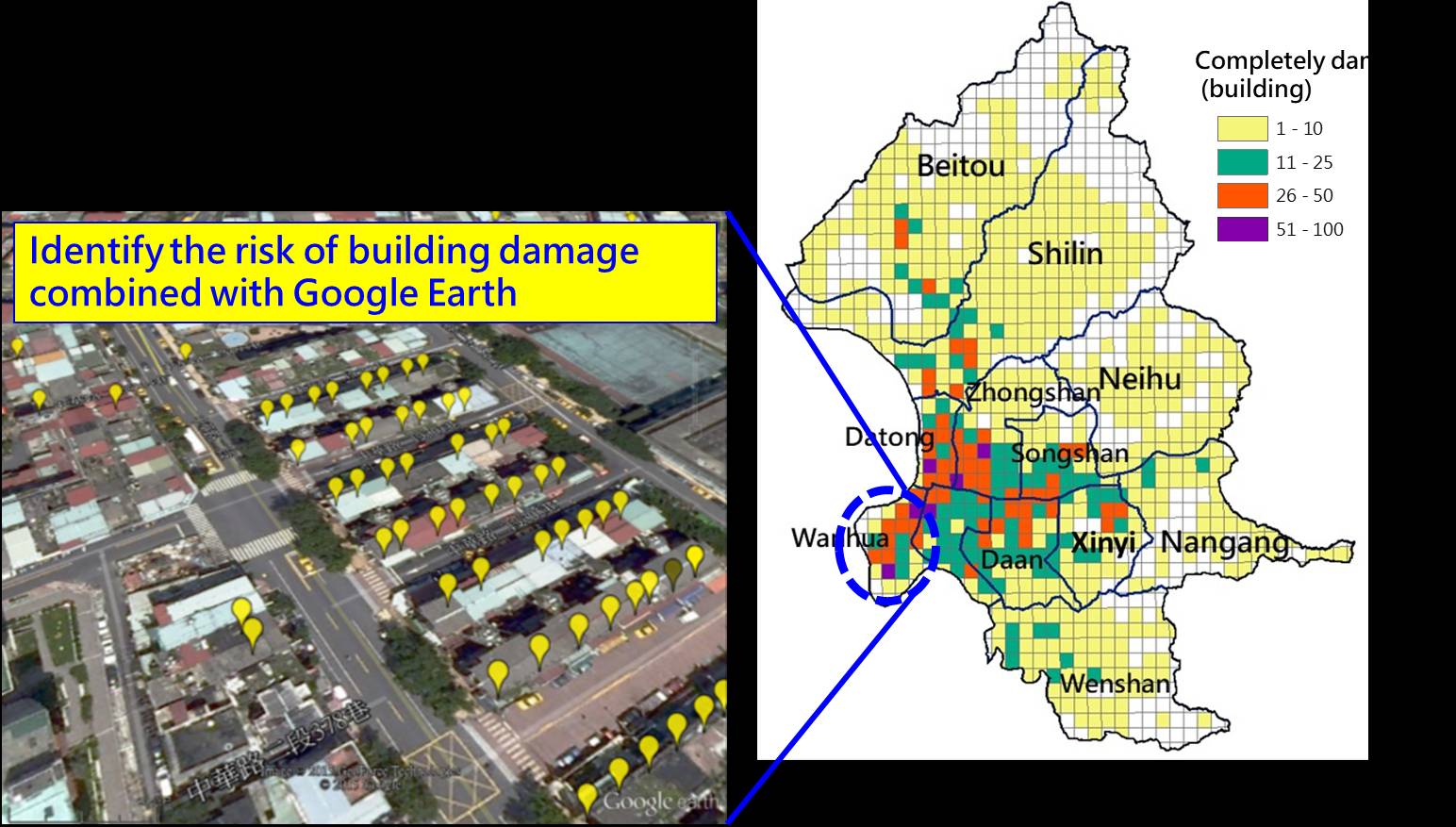
- Analyzed earthquake impact on old buildings in six municipalities
- Impact analysis on old buildings under seismic intensities of 5, 6 and 7
- Illustrated high risk building location on Google Earth software
- Provided analytical results to disaster prevention specialists in six municipalities
- Built 3-dimensional subsurface active fault plane
- Integrated geology equilibrium profile, earthquake location, and seismic refection survey to build 3D fault plane to a depth of 30 km from surface
- 3D fault plane beneath Hsinchu areas as an example
- Introduced Business Continuity Management (BCM) into Critical Infrastructure Protection (CIP) Implementation Strategies and established CIP management tools
- Revised CIP implementation guidelines with OHS, Executive Yuan
- Established CIP implementation plan and management framework
- Establish CIPM procedural structure of importance, vulnerability and resilience
- Developed CI information and data collection schemes
- Developed CI risk survey spreadsheet